
Weather experts have sounded the alarm over Hurricane Beryl’s “ominous start to the season”, as the Category 4 hurricane has suddenly increased to a stunning Category 5.
Beryl has already broken many records, as it has become one of the strongest hurricanes seen this early in the year. Now, officials are explaining that the next few months may be very difficult if Beryl is any indication of what is to come.
A Slow Start

Not too long ago, many experts were thinking that 2024’s hurricane season was off to a slow start — even after officials had forecasted that this season would be full of intense and potentially dangerous hurricanes.
Now, Beryl has arrived and has made up for this brief lull in hurricane activity. Already, Beryl has reached sustained winds of more than 150 mph as it went across the Windward Islands earlier this week.
A Record-Breaking Hurricane
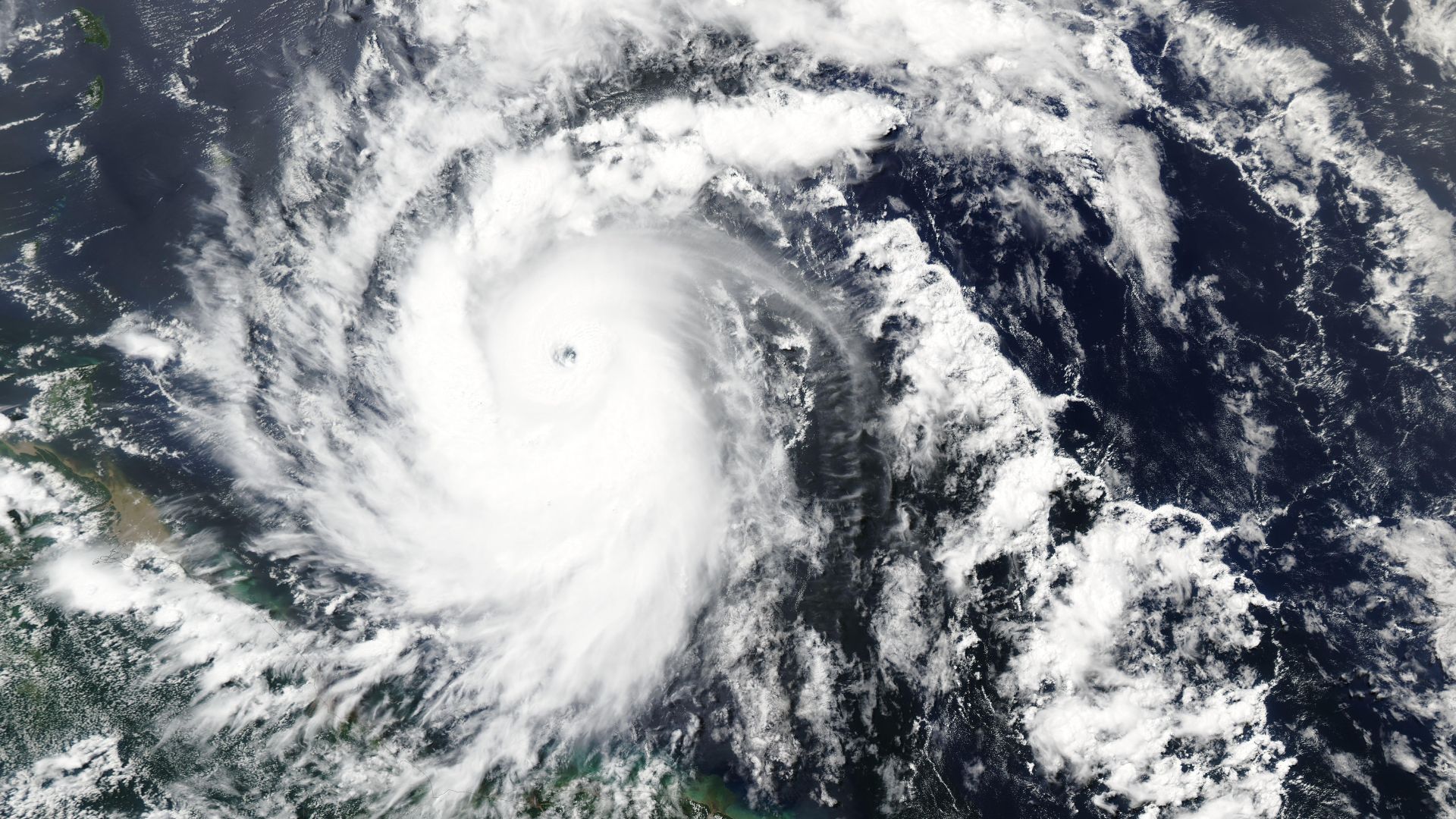
Beryl has already broken quite a few records — which has experts very worried. At first, it was the first hurricane on record to reach a major hurricane status prior to July 1. It is now the earliest Category 5 ever recorded.
Its very sudden increase from a tropical depression to a huge hurricane has also only rarely been seen in the past, as it jumped from 35 mph winds to 115 mph winds in fewer than 42 hours. Only six other Atlantic storms saw these types of increases, and all of these were seen after September 1.
A Warning Sign for the Rest of the Year

Thanks to all of these broken records, weather experts have explained that this could indicate a difficult hurricane season ahead.
Many analysts have already warned that 2024’s hurricane season could be much stronger than anything we’ve ever seen. Beryl seems to suggest this, as well.
A Difficult Hurricane Season?

Phil Klotzbach, a Colorado State University hurricane researcher, explained that normally, early storms don’t indicate what the rest of the year may see. However, Beryl has changed this.
Klotzbach said, “Normally, early season activity doesn’t have much of a bearing on the rest of the season’s activity, but when that activity occurs in the tropics and east of (about) 75 degrees W, it tends to be a harbinger of a very busy season.”
Analyzing Beryl

However, Klotzbach further analyzed the records that Beryl has broken and has come to the conclusion that this hurricane season may be very busy.
“Unfortunately, Beryl is breaking records that were set in 1933 and 2005 – two of the busiest Atlantic hurricane seasons on record,” Klotzbach explained.
A Dangerous Start to the Season

Meanwhile, Steve Bowen, the chief science officer of Gallagher Re, explained that Beryl is a “hugely ominous start to the season.”
He added, “If you were doubtful of the seasonal hyperactive forecasts, this should be a wake-up call.”
A Challenging Season

Now that 2024’s hurricane season is upon us, many weather experts are taking Beryl’s record-breaking activity to serve as a warning sign — and they hope people listen.
“Buckle up. It could be a challenging few months ahead,” Bowen said. “This is a massive warning sign for the rest of the season.”
An Amazing Hurricane System

Though many scientists have been warning the public about Beryl, others have also been able to analyze how amazing the system actually is, particularly because it was able to increase to a major hurricane system so quickly.
Sam Lillo, a meteorologist and software engineer for DTN Weather, said, “To develop and intensify to a Category 4 at that latitude, that’s really exceptional. And to have this happen way out east of the islands, that’s amazing.”
Other Brewing Storms

Beryl isn’t alone. On Sunday night, a storm system in the northwestern Caribbean and southwestern Gulf of Mexico increased to officially become Tropical Storm Chris.
Now, this storm is approaching landfall on the Mexican coast. Meanwhile, a third system is off the east of Beryl. The hurricane center has revealed that this system will likely also become a tropical storm sometime later this week.
A Month Ahead of Schedule

These three already named storms have also broken yet another record, as normally a typical season doesn’t produce three named storm systems until about August 3.
Therefore, 2024 is already off to a racing start and is about a month ahead of schedule.
How Beryl Became a Category 5 So Quickly

According to scientists, there are a variety of factors that helped Beryl become a strong Category 5 hurricane in such a short amount of time.
First of all, the unusually warm ocean waters in the Atlantic greatly helped. However, the hurricane’s compact size and weaker winds over the ocean allowed the storm system to pick up speed and strength in a quicker timeframe.